


Canterbury Quake
Fear and loathing in Canterbury

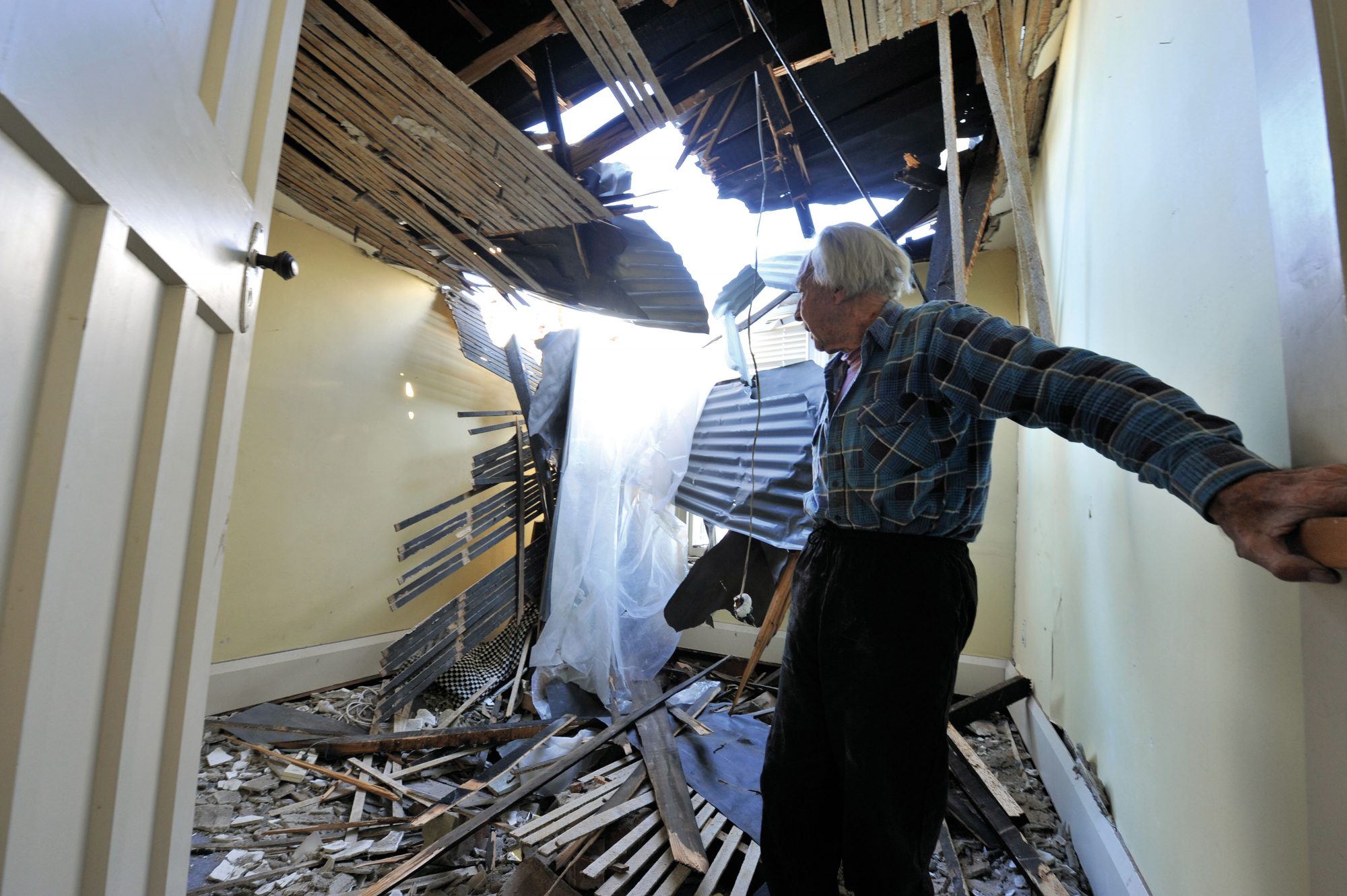
Saturday, September 4. Mayhem. Full volume, in-the-dark, chaotic mayhem. The ground roars. The floor rocks and tilts. What was once solid appears as insubstantial as a soft toy in the hands of a petulant toddler. Books are falling, spice jars tumbling out of the open pantry. We career down the hall, gathering jackets, shoes, yelling out to the rest of the family. For 15 seconds the house shudders and shakes before slowing to a ragged series of jolts. We find the torch, a radio (no batteries), candles (not a good idea, we learn later). We huddle around the table, ready to dive for cover or, if necessary, run outside.
[Chapter Break]
Four thirty-five am. Saturday, September 4. In Cathedral Square the bells ring out—no bellringer, just the force of a 7.1 earthquake—the first major earthquake in an urban area since the Hawke’s Bay disaster killed 256 people in Napier, Hastings and Wairoa in 1931.
In his first-floor flat in downtown Manchester St, bespoke tailor Mark van Roosmalen wakes suddenly, gets out of bed and tries walking to the strongest part of his apartment.
“I managed to keep upright—the lights had cut out—but I was definitely being chucked around. It was like a dog shaking off fleas. Everything was happening so quickly, it was madness, chaos.
And the sound—it was like a freight train coming right at you. It was just roaring.”
A glance out the window reveals a street strewn with masonry.
“It was all over the footpath—in that half light and that half-conscious state, I wasn’t sure if the whole road hadn’t opened up. It was surreal. We went downstairs and the footpath was about two to three feet deep in rubble from the crumbling parapets. People were out there—they were dazed, scared, confused. And it was freezing cold. I went for a walk down Manchester St. There was the Mexican restaurant Alvarados—all the walls blown out. And the tables still set.”
Within minutes, police and Civil Defence personnel are on the streets, responding to calls of imminent building collapse, feared flooding, lost relatives and, simply, panic. Those on the medical dependency register are taken to Christchurch Hospital (unscathed and operational throughout). The calm voice of National Radio All Night host Vicki McKay assures listeners there is no risk of a tsunami—although some in coastal areas have already fled to higher ground.
As power comes back on, friends and relatives ring through with their frightened—and frightening—accounts of inner-city devastation. News of the earthquake spreads, over fences, over airwaves and across the net.

By 10AM, a state of emergency has been declared. Cordons are put in place in the central business district as aftershocks continue to rattle already vulnerable buildings, and reports circulate of buckled bridges, burst water mains, gas leaks and potentially damaged sewage pipes. Civil Defence staff and structural engineers begin their inspections of inner-city buildings, attaching their verdicts on coloured placards—red for no entry, yellow for restricted entry, green for go. While workers labour without rest to get power and phone lines up and running (by night-time, 80 per cent of households have electricity), Mayor Bob Parker urges residents to conserve water, not to flush toilets, not to “rubber-neck”.
More police are flown into the city. On Monday, they are joined by army personnel to keep people out of restricted areas and to support those involved in the clean-up. At Christchurch Women’s Hospital, a record 21 babies are born in the 24 hours following the earthquake.
In the cardiology ward, new-patient numbers increase from an average two or three a day to eight or ten.
Emergency welfare centres are set up for those unable to live in their homes.
Over the next few days, information that an aftershock of around magnitude 6 can occur after a main shock of this size is suddenly treated as a certainty. There is a rush on bottled water, petrol, batteries. Unfounded rumours that the Lyttelton volcano complex had been nudged into action (based on an increased outflow at small sulphurous springs around the harbour) create a further flutter of panic.
For many, the large 5.1 aftershock on Wednesday, September 8, centred close to the Lyttelton tunnel, is the final straw. They load up the car and leave town.
[Chapter Break]
Four thirty-five am. Saturday, September 4. Ten kilometres under the ground, just 20 minutes west of Christchurch, a weakened fracture in the bedrock gives way to ancient stress, breaking and slipping in a massive sideways movement, releasing an estimated 2.8 quadrillion joules—or 778.4 million kWh—of energy. Thunderous primary waves rip through the overlying soils at a rate of five to seven kilometres per second. These are followed by secondary waves, spreading out vertically at about half the speed, tearing open the surface of the ground and spreading across the region. For about 15–20 seconds Christchurch is shaken, violently. Seismic instruments fortuitously placed in Greendale as part of a network spread across the Canterbury Plains pick up motions of 1.25 times the acceleration of gravity. Surfaces waves are felt as far north as Auckland and as far south as Invercargill.
Within minutes, seismic data is being assessed by the geophysical monitoring project GeoNet (run by GNS Science) and forwarded to the Ministry of Civil Defence and Emergency Management. The emergency bunker under the Beehive swings into operation.
By daylight, some 150 scientists, engineers, academics and researchers (including some from Japan and the US) are embarking on a massive programme of data measurement and damage assessment. The newly established Natural Hazards Research Platform—led by GNS Science and responsible for coordinating a collaborative response to natural hazards—is set up at Christchurch’s Environment Canterbury offices.
“One of the things we wanted to know was if the earthquake had been big enough to rupture to the ground surface,” explains GNS geologist Russ Van Dissen. “We knew it was on the cards, being 7.1 and shallow-ish, but it was important to get down as soon as possible before the record started being erased.”
They found an extraordinarily clear record—a ground-surface tear tracking east-west between Greendale to near Rolleston “like it knows what it wants to be doing, with a bit of a turn of a smile on its western end”. Roads, fences, farm tracks, shelterbelts and irrigation channels were offset in tidy kinks of up to 4.5 m, while north-west of Rolleston a 1.5 m bulge marked the less-pronounced vertical movement of the quake.
“The rupture expressed itself in a real striking way,” says Van Dissen. “It was like something out of a textbook with that east-west sideways motion really well expressed on the ground’s surface.”
But the profile of this earthquake is proving more complicated than the clean rip across the plains indicates.
The epicentre—the point on the ground above the first release of energy of the mainshock—has been identified north-west of Greendale near Charing Cross. It is here, it seems, that a thrust fault (the result of compression forcing one wall of weakened rock up and over another in a vertical movement) initiated a complex series of ruptures incorporating both thrust and strike slip processes, not unlike the composite profile of the 1994 earthquake at Arthur’s Pass.

In the Geological Sciences building at the University of Canterbury, active tectonics lecturer Mark Quigley points to a seismic energy graph.
“When you look at the energy release spectrum for this earthquake, you see this medium-sized boom, then BOOM, BOOM. The question is about this first one—it may relate to an overall single rupture process or there may have been some precursor event that delivered some energy and may—may—have had some influence on this main rupture.”
But locating such an event is a challenge.
“It’s like turning on the radio on moderate volume, then five seconds later turning on two louder radios playing a different song—getting those different signals is hard.”
Which takes us to Hororata, a pretty town close to the Canterbury foothills, the home of former premier and first mayor of Christchurch John Hall. It was he who helped to fund the small St John’s Church, now cordoned off from quake-daytrippers keen to photograph the shattered tower. And it is close to here, the theory goes, that another thrust fault added a determined jolt to an already complex seismic performance.
There is no sign of surface rupture here—many earthquakes, including the magnitude 7 one that hit Haiti in January, fail to break the ground surface. There is evidence, however, of rapid ground movement.
“You see interesting patterns in what we call graveyard geology,” says Quigley. “The gravestones that fell over on the north-south striking line fell over to the west; the ones that fell over on the east-west striking line fell over to the north.”
This implies that the ground was being dragged or jolted to the south-east as opposed to the east-west direction of the Greendale Fault.
There are cracks in the road, tiny signs of ground displacement, deer fences bowed and pulled apart—a subtle record, but a record nevertheless.
Then there are the personal stories, accounts of a large thump heard to the west (not east where the fault was) followed by a violent up-and-down movement—not proof in themselves but suggestive of a separate event from that which split the ground near Greendale.
“If there was a thrust fault here, where the fault motion was primarily up and down instead of a side-to-side motion like on the Greendale Fault, people might have felt like they were first being tossed up and down, unlike the people in Christchurch who felt a side-to-side movement,” says Quigley.
Put the clues together—the fences, the cracks, the stories, the subsequent north-east trending line of thrust fault aftershocks—“and at the moment some of us think that there is something [south-east of the township] that may have ruptured during that event. It may have been before or after, we don’t know.”
[Chapter Break]
Pacific ring of fire—it is a ridiculous description for this green and disciplined landscape stretching out between the Southern Alps and the blue-grey of the Port Hills. The fences and shelter belts, the small towns with their craft shop cafes and heritage homesteads, all seem a far cry from grinding tectonics and massive geological stress. Yet much of the Canterbury Plains owes its existence to the gravel and debris washed down from the 480-kilometre-long Southern Alps, themselves a product of the Pacific and Australian plates colliding into each other in constant readjustment of the Earth’s crust—the New Zealand link in the 40,000 km Pacific ring of fire.
Scientists have long known that a network of faults lies under the surface of the plains—the risk of a large earthquake at Porters Pass has long been recognised, and seismic surveys have already revealed buried faults just north-west of Christchurch.
But this fault was not on the map.
Embedded in 20 million-year-old greywacke bedrock in the Canterbury Basin, it was buried under several hundred metres of glacial deposits 15,000 to 16,000 years old, perhaps older.
Even its east-west orientation is surprising. While it is consistent with large offshore faults on the Chatham Rise east of Banks Peninsula, most faults in this region run north-east.
But if the location and direction of the Greendale Fault were unexpected, the potential of a shake of this intensity was not. Hazard models for Canterbury have long allowed for a magnitude 7.2 earthquake.
The resulting damage to the city’s buildings, says University of Canterbury structural engineer Andy Buchanan, was largely predictable.
“It reinforced what we already knew—that unreinforced masonry is hopeless but it can be strengthened, and that strengthening works. The pre-1930s brick buildings that fell down were not subjected to any kind of design for earthquakes, and they were the same buildings that fell down in the Napier earthquake.”
But, as the debate heats up over the rebuilding of the city and the seemingly speedy demolition of some of its most gracious—although, perhaps, neglected—heritage buildings, Buchanan is urging caution. If the ground shaking experienced by Christchurch had been as high as the city’s buildings are designed for there would have been more damage. More research is vital, he says, to future-proof buildings against potentially larger earthquakes.
“One of the biggest things we’ve learned from this earthquake is that you have to look not only at the buildings above ground but the soil underground.”
It is here, in the soil under Kaiapoi and the Christchurch suburbs of Avonside, Bexley and Brooklands, that the impact of the earthquake was dramatic and (at the time of writing this) ongoing.

The reason? Liquefaction—sodden and unstable soils turning to mush as a result of violent ground motion, here leaving a trail of warped floors, cracked roads, broken pipes, silt- and water-logged streets. In Kaiapoi alone, 32 km of water pipes and 37 km of roading were damaged. By September 25, 96 residential and commercial buildings were still deemed unsafe.
Misko Cubrinovski, at the University of Canterbury’s Civil and Natural Resources Engineering Department, explains liquefaction: “During shaking, if the ground is dry, the soil tends to densify. But if you have water in the pores of the soil it can’t densify—the volume cannot change. The only way to densify is to squeeze the water out. Because the earthquake is very short, there is not enough time for the water to escape, so the pressure on the water is going to increase.”
Under this pressure, loose soil particles become suspended in water, no longer capable of carrying or transferring weight. Ongoing pressure pushes the miry fluid upward. The result: soil and water erupting up to the ground surface in a bubbling mass of mud and silt.
Liquefaction in the areas affected was not unexpected, but no one thought it would be so extensive.
“The extent of damage is quite significant, bearing in mind the level of ground shaking,” says Cubrinovski. “But that probably goes with the fact that those soils were slightly looser than on average.
“But we shouldn’t say we’ve had a big one, let’s not do anything about it. What we would like to improve is the ground engineering—and it can be addressed.”
Soils prone to liquefaction can be remedied through processes of compaction, as was done in the new town of Pegasus, near Woodend, which suffered little damage. This difference in soil consistency may also have affected how residents experienced the quake. When the motion at bedrock level is of relatively low amplitude, soft soil sitting on top of that bedrock will amplify the motion.
But very strong accelerations at bedrock level create a lot of deformation and liquefaction in the soft soil, dissipating energy and reducing the acceleration at the surface. The resulting motion, says Cubrinovski, is like being on a ship—“very slow but large amplitudes, whereas on firmer ground it will have high frequency but smaller displacements.”
[Chapter Break]
A month later, Hagley Park is awash with daffodils, trees are in blossom, whitebaiters are dropping nets into the (admittedly) sullied waters of the Avon and Heathcote rivers. Around the city, roofs still bear the bandages of missing chimneys. The spires of the Arts Centre are bound by tape and ply supports, and areas of Colombo St are still cordoned off. An estimated 300–400 businesses have been forced to close, and 390 buildings are still red-stickered. While many residents in Avonside and Bexley are still having to use Portaloos and restrict water use, much of the conversation is now turning to matters of law (rent on damaged buildings, insurance payouts, income support), the estimated $4 billion worth of costs to individuals, businesses, the Earthquake Commission and insurance companies, and plans for the rebuilding and strengthening of the inner city. Already the Christchurch City Council has introduced a policy requiring certain buildings to be strengthened to 67 per cent of the Building Code—twice as strong as the previous requirement.
Everyone agrees that the devastation could have been worse. The fact that no lives were lost is testimony to the level and quality of engineering and sheer good luck—two hours earlier or later and the streets would have been full of people.
Yet only last night, a magnitude 5 aftershock rocked the province—one of approximately 840 quakes magnitude 3 and above that have rattled the city since September 4.
With up-to-the-minute data from the GeoNet or canterburyquake websites, we residents have become seismic experts, speaking knowledgeably of the latest 4.2 or 3.8 aftershock. Where initially these quakes tended to cluster along the main fault trace, the aftershock zone has expanded to the east and west. It is now over 60 km long and extending into surrounding areas—an expected pattern of readjustment akin to the slow-motion cracking of a windscreen as smaller faults give and the disturbed land settles down, a pattern that may last for months.
And while the tremors are becoming less frequent, their severity, recorded by an existing network of 40 instruments augmented by 24 portable earthquake recorders deployed by GeoNet, is taking longer to decrease, fuelling fears that, while this earthquake lessens the risk of another rupture on this fault, it may trigger another elsewhere.

Quigley squeezes one end of his mousepad—the other end remains unaffected.
“Even though there’s quite a bit of displacement at the centre of the fault, the other end doesn’t even know about it. Aftershocks accommodate that change in volume, but that change falls off at a distance.”
Historic records seem to show earthquakes occurring in clusters. There was a bunch in the 1880s and ’90s—in 1888, a large earthquake on the Hope Fault in North Canterbury, heralded by three weeks of noisy foreshocks, caused widespread damage and sent the spire of Christchurch Cathedral to the ground. According to the Lyttelton Times, “the melancholy appearance of the wreck strikes every eye”.
There was another cluster in the 1930s and ’40s, beginning with the 1929 Arthur’s Pass earthquake on the previously unidentified Poulter Fault followed three months later by the 7.8 Murchison earthquake.
But such apparent clustering could be coincidental, especially when you add in the slightly smaller earthquakes of magnitude 5 or 6.
“The clustering of earthquakes happens at some times and not others,” says Van Dissen. “The North Anatolian Fault in Turkey started rupturing in the late 1930s and has basically been unzipping for the last 60 to 70 years. That’s clustering. But we can’t predict it, and that’s largely because we don’t know how close surrounding faults are to failing. This might give another one a nudge but we don’t know whether it was the straw that broke the camel’s back or whether we could add another four or five bales of hay.”
The elephant in this scary room of earthquake prediction is, of course, the famed Big One, the Alpine Fault cleaving the South Island from Marlborough’s Wairau Valley down though the centre of the island then over to the West Coast and out to sea near Milford Sound.
It is a major strike slip fault with occasional thrust segments, an historic record of New Zealand’s separation from Gondwanaland accommodating up to three-quarters of the annual 35–38 mm movement between the Australian and Pacific plates in the central and southern parts of the South Island.

Magnitude 8 earthquakes on the Alpine Fault are said to occur every 200-300 years. Based on an analysis of the growth rings of cedars, the last known earthquake of such a magnitude was in 1717.
Surely we are overdue?
“Before 1717, the previous two quakes were 4–500 years apart,” argues Kelvin Berryman, the GNS scientist directing the Natural Hazards Research Platform. “So it’s not imminent—perhaps as much as a hundred or more years away.”
There are suggestions that seismic waves from a large earthquake can cause microcracking or change fluid pressures in other faults. In recent weeks, the Alpine Fault might have had a slight increase in micro-seismicity and a small change in the temperature of hot springs—but if a fault is not already late in its seismic cycle, says Quigley, if it is not “amped and ready to deliver an earthquake”, then these processes are likely to be minor.
“We’re talking about deep massive forces here and the interaction between faults. If you have a whole system locked up with a lot of faults ready to go late in their seismic cycle, microfracturing in the Alpine Fault may bump the due date forward a small increment of time, but only may, possibly.”
Even suggestions that small changes in temperature or moisture can trigger a collapse are just that, he says—suggestions. Earthquake prediction may be the holy grail of seismological research, says Berryman, but we’re not there yet.
“All we can say is, on average, the Hope and Alpine faults will have more earthquakes than others.”
“Prediction does not make a resilient community,” says Van Dissen. “It doesn’t tell you how to recover after an earthquake, and the quickness of that recovery is dependent not on whether you are able to predict the earthquake but on what you do before an earthquake.”
This includes storing torches, batteries, emergency food and water. While a survey of Christchurch and Canterbury residents completed just a week before the earthquake found that most had such items, only 13 per cent imagined being affected by an earthquake in the following year.
“A lot of people went down the line that it won’t happen tomorrow,” says GNS social scientist Julia Becker, “so they postpone their preparations.”
Being able to access social support after such an event is also important. Despite a smattering of thefts and rip-off scams, communities have rallied together, helping neighbours, clearing rubble. A Facebook appeal saw thousands of university students clear whole streets of mud and silt; at St Martins New World supermarket, staff handed out chocolates.

on their first day back at school.
For some, this wasn’t enough.
“Some people catastrophise,” says Ian de Terte, a clinical psychologist at Massey University. “They jump from A to Z—Z being ‘I’m going to die and get swallowed up by an earthquake’. Instead of staying at A or Z, we should stay at M.”
Following an event like this, he says, 80 per cent of people will be fine.
“Fifteen per cent with minor psychological problems will recover and five per cent may have long-term difficulties. Some literature says if you go in and do any intervention, you can make matters worse, but if people are struggling they should seek support through their GP or social networks—a little bit of tweaking now is easier than in six months’ time.”
As residential areas shuffle closer to coastal areas, as previously unused land is tagged for new subdivisions and as the insurance sector identifies more sophisticated means of risk analysis, discussions now, says Berryman, should focus on the economic impact of natural hazards.
“New Zealand needs to be thinking how to manage its future risk and not be surprised by things that are not very surprising.”
It’s about deciding where to draw the line, he says, between tolerable impact and acceptable risk.
“For example, Homer Tunnel is closed every year for avalanche risk—it’s intolerable to allow people to be exposed to that risk. We can’t lower the risk of an earthquake, so what level is going to be acceptable from economic and life-safety points of view?”
While New Zealand lags behind at the lower end of OECD investment in scientific research, particularly by industry, the most obvious lesson from the Canterbury earthquake is the need for more investigation into the country’s geology and more research to support the structural and geotechnical engineering processes that can ensure our safety.
As Berryman says, we live in a tectonic area. We will have more earthquakes and we will have stronger earthquakes. “So we either go to live in Queensland with the snakes or we adapt to it.”


