Accuracy above all
In the 19th century, mariners relied on “faith in God and an Admiralty chart”. Despite the revolutionary impact of satellites and global communication networks on the task of navigation, the essence of safe sailing is still a sound chart.
When James Cook first sailed the Endeavour into the Bay of Islands, his running survey of the New Zealand coastline was in its seventh week; it almost ended there, on the night of Tuesday, December 5, 1769. The Endeavour had sailed in the morning on a light breeze, but during the day the wind dropped away to nothing. By evening the ship was caught in a tidal current and in danger of being swept on to the rocky coast.
Francis Wilkinson, the Mate’s mate, wrote in his journal:
“The Capt. ordered the pinnace to be hoisted out to go ahead and tow the ship… all this time the Indians on shore making a great noise and rejoicing at our misfortune, expecting us to be a prey for them…”
The vessel was successfully towed out of danger, but an hour later misfortune struck again: the ship hit a submerged rock . . . “which we took for a whale as the sea broke over it seldom and [it had] much the appearance of one, but luckily we were to windward and as she struck on the larboard bow [she was] thrown clear of the rock without any perceptible damage.”
Cook named it Whale Rock, and sailors to this day remain wary of the wily leviathan that only shows its face when the seas are rough.
Although Cook didn’t have time to make an accurate survey of the Bay, he recommended it as affording “good anchorage and every kind of refreshment for shipping”. Two centuries later, those “refreshments” of sun, warmth and calm weather,—together with a pressing need for more accurate survey data—had attracted another survey ship, HMNZS Monowai, hydrographic flagship of the Royal New Zealand Navy.
[chapter-break]
At 6 AM exactly the shrill whistle of the bosun’s call slices like a scalpel into the subconscious, severing the waking mind from the clinging strands of sleep. “Wake-ee, wake-ee, rise and shine!” comes a voice over the cabin loudspeaker. At that time of morning it has all the melodiousness of a concrete mixer.
To a civilian unfamiliar with a ship, finding my way around is like playing snakes and ladders; I must negotiate a confusing network of narrow corridors, knee-high heavy steel doors, and skinny vertical ladders. Though this is a ship concerned with making charts, I find few clues to tell me where I am on board. No helpful signs; no maps with arrows pointing “You are here”. Fortunately, with a ship’s complement of 126 persons there is always someone around to point me in the right direction.
At 89 metres in length, Monowai is the largest of the Navy’s three survey ships. HMNZS Takapu and Tarapunga, both 27 metres long, are inshore craft. Together, the three vessels collect the hydrographic data which is the basis of all recent New Zealand nautical charts.
Most of the early New Zealand charts were published by the British Admiralty, but in 1949 the New Zealand Navy set up its own hydrographic service. Today, that service is made up of both naval and civilian staff, and is responsible for the surveying and charting of our harbours, coastal waters, offshore islands, and the surrounding area of the South Pacific that has been assigned to New Zealand under charting arrangements with Britain, Australia and the International Hydrographic Organisation.
As well as undertaking survey work, hydrographic personnel can be called upon to assist South Pacific nations in defining the boundaries of territorial seas and economic zones, and calculating the median line between adjacent countries. They may also act as expert witnesses in court cases involving infringement of fishing limits, by certifying the exact position of vessels under prosecution.
All three hydrographic ships also take part in a wide range of general naval activities, such as ceremonial functions, providing transport and living accommodation for VIPs, and disaster relief. Last year, personnel from Tarapunga were sent to Western Samoa to carry out clearance surveys of the main harbours after Cyclone Ofa ravaged the islands. On the lighter side, the Duke of Edinburgh watched the start of the Auckland to Punta del Este leg of the Whitbread Round the World Yacht Race from Tarapunga’s decks.
Weather plays a decisive role in hydrographic survey work. Foul weather keeps the small boats carried by Monowai from working, and sudden changes can lead to dangerous situations. Boats that have been launched in calm conditions sometimes have to be retrieved from rough seas. Lieutenant Clive Holmes, Monowai’s survey operations officer,explains: “It’s mainly the swell that causes problems, smashing the boats against the side of the ship as they are hoisted, and swinging them wildly from the davit arms. We do not launch the boats if there is a possibility of more than a one to two-metre swell or 25 knots of wind developing during the day.”
The weather is not the only factor that interrupts the planned survey schedule. The Bay of Islands survey was put aside when the Hydrographic Office received a request from the Department of Conservation for a survey of the approaches and inlets between Port Ross and Carnley Harbour on the east coast of the Auckland Islands. This area of previously uncharted water is being used by cruise ships on nature tours of New Zealand’s subantarctic islands. The potential danger was pointed out by Monowai’s present captain, Commander Peter Usher.
“We surveyed within an area five miles off the coast, with 75 metres between survey lines. We had look-outs posted on the bridge, as we had no knowledge of dangers in front of us. Often you get a feel for what the seabed will be like from what you can see on the land surface. The rock features of the land were abrupt, of basalt origin, and these were reflected in the nature of the seabed.
“The ship was steaming a line when the echo-sounder showed readings shoaling from 80 – 30 metres very quickly, then 30 – 18 almost vertically, so we stopped and called the sounding boat. They found a depth of seven metres completely uncharted and lying about a mile off the coast. For a cruise ship with a draught of eight to ten metres, that sort of peak is a disaster waiting to happen.”
[chapter-break]
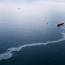
Monowai is on her second visit to the Bay of Islands as part of a survey to produce a new large-scale chart. With hundreds of small boats using the area for recreation in the summer, the present chart—based on a number of surveys dating back to the 1920s—is inadequate. It is not that the earlier surveys were inaccurate, rather that they were small-scale surveys, and so had sounding lines which were relatively far apart. The gaps could contain uncharted rocks, or even a wreck, waiting to snare the unsuspecting mariner.
By 7.15am the work teams and their equipment are ready to be loaded into the three ship’s boats: Seagull, Pelorus, and Astrolabe. The boats are lowered by davit with the crew in place—a manoeuvre that can take place when the ship is steaming slowly or at anchor. Boats are launched on the lee side of the ship, and in the old days oil was used to smooth out the water. This practice was stopped in the mid-1950s.
One of the first jobs for the survey team is to locate the shore stations—known positions on land (marked with a piece of brass pipe or plate) which were set up on Monowai’s last visit. Unfortunately, the local council had put in a new stretch of footpath on the Paihia waterfront, and had concreted over one station marker, and another had been knocked off Russell Wharf.
On a nearby hill a young pohutukawa had put on a growth spurt and obscured the view. Cook and his officers would have chopped it down, but in these ecologically enlightened days the Navy defers to the tree and sets up a new marker.
Once the station markers are located, trisponders are set up over them. These devices transmit a microwave signal to a computer on the survey boats, enabling the crew to fix their position precisely when taking soundings. Trisponders often have to be set up on rugged promontories with a clear view over the sea, and carting them there and back can be a difficult task. A helicopter makes light work of it, but these beasts of burden are not always available. While Cook’s men were totally reliant on their feet and blades to slash their way through dense bush, today’s”jolly Jack tar” can come up with ingenious schemes to save his feet.
While working in Tolaga Bay on the North Island’s East Coast, the shore party borrowed horses from a local farmer and formed their own transport company, the “Tolaga Bay Light Horse”. With number-plates strung around their necks with bailing twine, and a great understanding of Maori, but no English, the horses provided entertainment as well as cartage.
During the survey of French Pass, a farmer on Forsyth Island provided a more advanced form of transport. Lt. Cdr. Ian Martin (Rtd) recalls: “He took us to a shed littered with old motorbikes. We spent some time working on what we could fit together into a ‘going bike’ and took off up the farm track, through metre-high thistles, dressed in shorts on bikes with flat tyres and no brakes. Going up was fun, but coming down…” Monowai now carries an all-terrain vehicle for transporting equipment where the Landcruisers won’t go.
Trisponders can be used only within 80 kilometres of the coast, and need a line of sight. They are run by two large batteries, which have to be guarded in populated areas to prevent theft. Crew members assigned this duty can usually look forward to a long, boring day, but there have been moments. In Fiji, a sailor was chased up a tree by wild pigs, and spent the rest of the day there, waiting to be rescued when the helicopter returned. In Pomare Bay, Northland, Able Hydrographic Assistant Robson was shot at. He dived for cover, but soon realised it was only “young kids up the hill taking pot-shots with their air guns.”
The heart of a survey is the taking of soundings, and more hours are spent doing this than on any other activity. The echo-sounder takes depth measurements at a rate of up to six times per second, depending on the depth. Each measurement is made by timing the interval between transmission and reception of an acoustic pulse which travels from the boat to the seabed and back at a speed of approximately 1500 metres per second (five times the speed of sound in air).
By sounding continuously, a pro‑file of the seabed beneath the boat’s track is obtained. This is known as a sounding line. A succession of parallel sounding lines is run across the survey area, and the contours derived from the resulting profiles build up a picture of the seabed. As the depths are collected, regularly spaced positions fixes are taken and recorded.
This procedure is repeated all day, every day, until the area covered by the survey is completed. In a calm sea, with the hatches open and sun streaming in, it’s a pleasant enough job. If it starts to rain, or the wind whips up the spray, the hatches have to be shut, trapping in fumes that test the stomach of even the most hardened sea salt. Echo-sounder operators have been known to work with a bucket between their knees!
If a rock is discovered, or suspected to be present, a special investigation is carried out. This involves the same procedure as sounding, but a much closer network of lines is run over the locality. Even so, isolated pinnacles, wrecks and other obstructions can easily be missed if they lie between sounding lines. The use of a side-scan sonar, which scans a wide rectangular area on either side of the sounding line, or techniques such as wire sweeping (when a wire is stretched between two boats and run through the sea at a fixed depth), assist in finding these hidden menaces. In some cases, where the water is too shallow to operate the boats safely, divers use a simple tape measure to record a rock’s exact depth.
For his soundings, Cook used a hand lead of 7lbs and a deep-sea lead of 141bs with 200 fathoms of line. Each lead was “armed” with tallow placed in a recess in its base for taking a sample of the seabed. The Monowai achieves a more accurate sample by using a winch and grab or corer.
[Chapter-break]
Tide readings are another important part of a hydrographic survey. The depth soundings are related to the height of the tide at that particular time, and have to be reduced to the lowest predicted tide before being incorporated into the final chart. The level usually selected as the standard or datum for soundings is the lowest astronomical tide (LAT). This is the lowest level to which the sea will fall under average meteorological conditions, and it can only be accurately determined by observing the tide levels over 18.6 years (one cycle of the moon’s nodes).
The main influences on tide height are the gravitational effects of the moon and the sun, the weather (a high pressure system forces the sea surface down by a few millimetres; a low pressure system has the opposite effect), the shape of the land and the size of the ocean the tide is in. The path which the incoming or outgoing tide travels around the land also affects the difference between high and low water.
To gain a clear picture of what the tide is doing, hydrographic surveyors must make tidal observations over a period of at least 25 hours. This is because the moon completes one rotation of the earth in 24 hours and 50 minutes, during which time there are two complete tidal cycles. Observations are made every half hour, and then every ten minutes on the turn of the tide to make sure the nature of the change is recorded.
French Pass, the narrow stretch of water between D’Urville Island and the South Island, can provide hair-raising moments for tide observers. With the fastest tidal flow in New Zealand (eight knots), the channel itself can only be worked safely for about half an hour each day. “If you get caught up in the flood or ebb, the adrenalin starts to pump,” says Ian Martin.
Leading Hydrographic Assistant Corrie Donselaar describes the power of the tidal stream in French Pass: “While taking Tarapunga through the pass against the flow, one engine lost revolutions. We spent ages creeping forward at one knot before it picked up and we were able to get out. Half an hour later, Takapu tried to come through. She was swung around beam on and tossed back out.”
Several methods were used to try and measure the speed of the tidal stream through the Pass. Dropping floats proved ineffective. The swirls and eddies spun them out, giving no true pattern of them going through the waterway. In the end it was decided that the best method to get a consistent reading was to try and stay in one place in the Pass and use a current meter.
Tarapunga’s aluminium boat Titi, with three people aboard, was tethered between the two lighthouses. “It was an incredible feeling,” recalls Ian Martin. “The land was still, the boat was still, but the volume of water racing either side of the boat was phenomenal. The water pressure was so great that it bent the outboard rig to which the current meter was fitted. The lines stretched between Titi and the lights whistled and warped.”
Surveyors worked in stretches of six hours, and were then relieved. On one occasion, the coxswain of the inflatable taking out the relief team stalled the engine in the process of stopping, and the current threw the Lancer towards Titi at eight knots. The men ducked the hawsers but the motor got hooked up. “We had to let Titi go and spin out of the way. We missed that reading!”
A more relaxed method of measuring tidal flow is to use a log-ship—a piece of wood, weighted at one end so it stands vertically in the water, almost submerged, and attached to a length of line which has knots tied in it at measured intervals. Over 200 years ago, Cook was using a log and line in the Bay of Islands, although his purpose was slightly different. The wooden log was dropped into the sea, and as it ran astern the Endeavour’s speed would be measured by the knots on the line attached to it, timed against an hour glass. The term “knots” referring to a ship’s speed derives from this practice.
Cook fixed his position at sea using sextants. Then, from the known position of his ship, he took frequent bearings and horizontal angles of prominent land marks, and plotted them. On his first voyage, Cook carried no accurate chronometer. Although a design by watchmaker John Harrison had been accepted by the Board of Longitude, it was still undergoing sea trials.
To work out his longitude at sea, Cook and his astronomer, Charles Green, made frequent calculations of lunar distance—a procedure which required four people to work together taking angles and altitudes with sextants, noting the time (as best they could), and recording the details. Because the calculations involved were long and difficult—especially so on a swaying deck—Cook went onshore whenever he had the chance, and made celestial observations. These enabled him to work out extremely accurate positions. At Mercury Bay, for example, his journal records a latitude of 36° 48′ S. The current chart gives the location as 36° 52’—just four minutes’ difference.
On his second voyage, with the Resolution and Adventure, Cook carried a chronometer made by Larcum Kendall to Harrison’s design. With this instrument on board, William Wales, the ship’s astronomer, was able to correct the mistakes Cook had made in laying down the position of the islands.
Today, thanks to satellite navigation, positions accurate to within a few metres are available at the press of a button. Such advances make Cook’s methods seem primitive indeed, yet a testimony to his mastery as a surveyor is the fact that part of one of his original charts is still in use today: the plan of Pickersgill Harbour on the chart of Dusky and Breaksea Sounds.
While the excitement may belong to those manning the small boats, the nucleus of hydrographic activity is the Monowai’s chart room, where the incoming data is collated and presented as a maze of numbers on a “fair sheet”.
During the day, those “drogs” (Navy shorthand for hydrographic surveyors) not out in the field work on board transferring data. The chart room is a scene of quiet concentration: heads bent low over charts, a clear voice calling figures from the echo-sounder trace, the rustle of paper and the soft tapping of a computer keyboard. In the evening the atmosphere is noisier, with officers and ratings ribbing and being ribbed on the events of the day, as when Able Hydrographic Assistant Terry Kyle grounded Seagull on a sandbank, and had to sit there for several hours before floating off.
The fair sheet shows the depth in metres at the exact spots sounded, as well as tidal data. In Cook’s day, turning the fair sheet into a working chart took up to six months. Two centuries of technological change have accelerated the process considerably, and there are still more changes coming. A new computer system called HADLAPS (Hydrographic Automated Data Logging and Processing System) will be installed in November 1991 on the survey vessels. It will do in hours what it now takes days to complete in the chartroom.
Other changes are apparent, too. A whiff of perfume as you pass a cabin, a glimpse of skirt in the corridor—signs of a new order for the Navy. Following the successful ‘Women at Sea’ trial held in 1986, Monowai and three other ships have had facilities for women installed. In the Bay of Islands there were 21 women on board, six of them hydrographic surveyors in training.
In such a traditionally male domain, their presence has been a frequently heated topic of discussion in the wardroom. While some officers express doubts about the effect on discipline and morale, the consensus among younger officers is that the presence of women is good for the social dynamics on the ship.
The ratings agree. With the exception of a few occasions when “being a woman” may cause resentment, there is an easy relationship between the sexes, though close fraternisation is forbidden for disciplinary reasons.
[chapter-break]
The challenge of turning a page of hand-drawn numbers into a document that is accurate and reliable, and which can keep a vessel in the water and off the rocks, is the task of civilian staff at the Hydrographic Office in Takapuna.
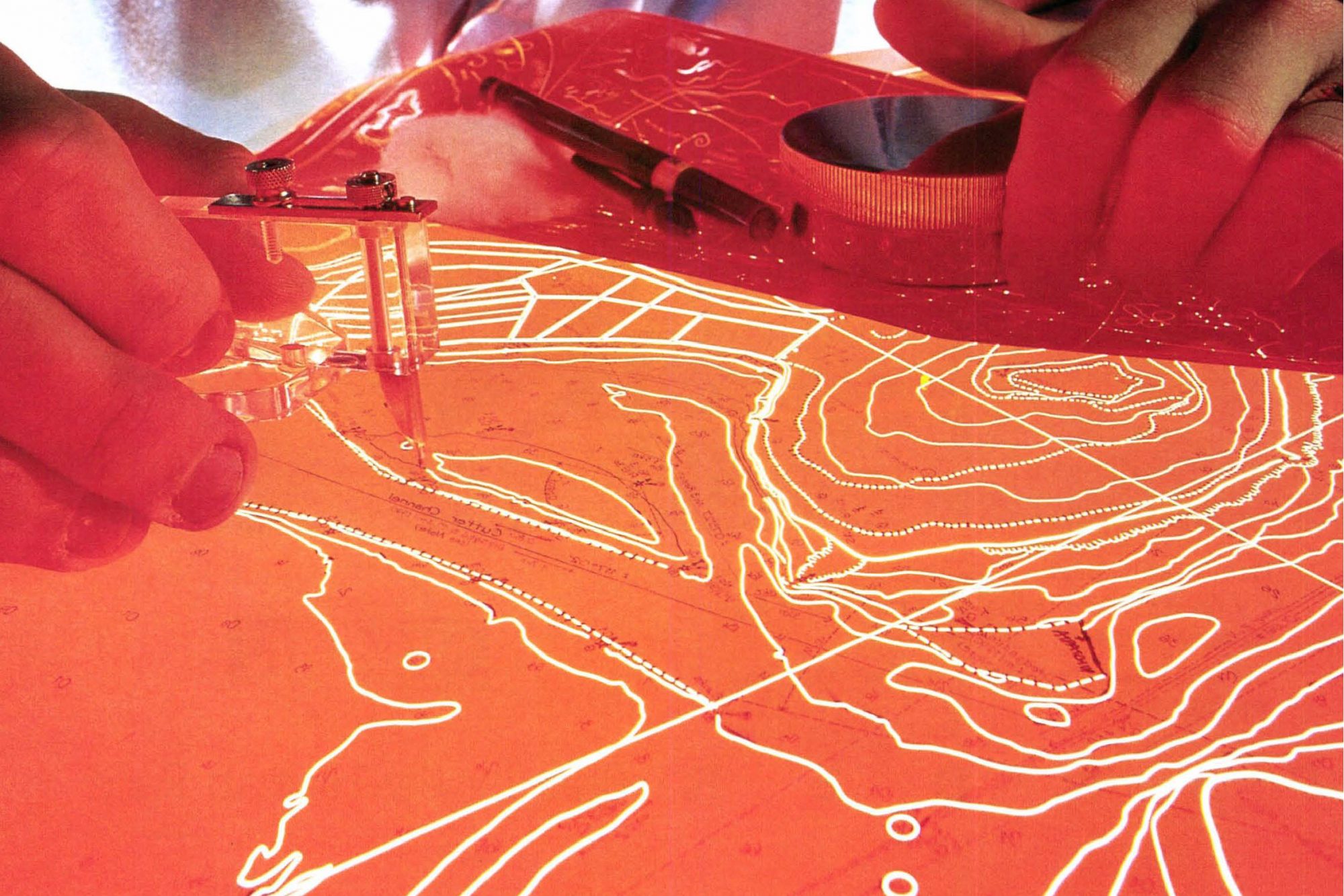
There, my introduction to chart-making starts not with explanations about pens and compasses, but, surprisingly, with a lesson in spheroid trigonometry from the Superintendent of Charting, Margaret Chappell. Because the earth is round, any two-dimensional map of its surface, either dry land or seabed, will contain certain distortions. These can be overcome mathematically by making various assumptions which are described as a projection. The first step in making a chart is to choose the appropriate projection and, using trigonometric calculations, scribe that projection as a network of latitude and longitude lines and outer borders, which together form the framework of the chart.
The actual scribing is done with a plotting machine mounted with a sapphire cutting tool which etches the chart framework on to a high stability coated film fixed to the plotting table. The process produces a negative (or reverse) image of high quality linework called a scribe. The scribe is photographically contacted to positive to give a same-size black-on-white image on matt film. This document, the compilation, gives the cartographer the chart framework on a surface which will accept the drawing pen.
All the chart data is then hand-drawn on to the compilation. The finished compilation is made up of details from the fair sheet, topographic data and a host of other details, including magnetic variation, the position of beacons and lights, the location of prohibited anchorages, yacht moorings, fish farms, cables, and so on.
The details from the fair sheet are selected by ringing depths, danger spots, rocks, small islets, shallow areas, pinnacles and so on. Overlay tracings are prepared by the cartographer by copying only the selected details, and these tracings are then photographically reduced to the scale of the chart. Each tracing reduction is then fitted by latitude and longitude or by mapping grid beneath the compilation sheet, enabling the cartographer to trace the detail directly on to the compilation.
Dozens of separate sources of information may be used in the compilation, and the resulting document is extremely complex. Once it has been thoroughly checked and amended, it is returned to the cartographer for the preparation of the final drawing.
First, the compilation image is photographically transferred on to the original scribe sheet, giving a black image on the opaque orange scribe coating. This time, instead of creating a positive image (black-on-white like the compilation) the cartographer must work in reverse, scribing all of the linework on to the high stability film. The cartographer uses a hand-held swivel-headed instrument mounted with a sapphire cutting tool, which is drawn carefully along the line images, cutting through and removing the opaque coating and leaving sharp lines on the clear film base.
The completed scribe goes to the photographic department, where it is contacted to positive again. Lettering, symbols and soundings are cut from self-adhesive stripping film and stuck to the positive linework, which has the compilation accurately registered beneath to act as a positioning guide. The resulting film is the final black drawing or “master”.
Three additional colours are used on navigational charts: green for land areas, blue for shallow water (usually dark blue for water up to 10 metres deep and light blue for 10 to 30 metres) and magenta (red) for additional details. The magenta is prepared by using self-adhesive stripping film, and sticking the required detail in position on clear film, while the blues and green are produced by cutting masks (using a special peel-coat film) on separate sheets of film.
The positives of the three colours are checked against the final (black) drawing, and then all four colours are contacted to negatives. These are retouched to get rid of dust spots and scratches which could appear on the final chart and be misinterpreted as small islets or rocks which don’t exist.
The negatives are then sent away for the making of plates, and, finally, printing, using the conventional offset process. To keep a constant supply, chart reprinting is carried out every three months, and stocks are regularly updated by screen printing, an innovation developed by the New Zealand Hydrographic Office and now being adopted elsewhere in the world.
One of the Hydrographic Office’s important functions is the announcement in print and, if warranted, on long-range radio of any amendments to charts that are reported and any factors that may affect safety at sea. The Notice To Mariners is a weekly publication of alterations, corrections to lights, changes of buoys, depth soundings, radio signals and so on.
Navigational warnings are made whenever there is a threat to ship-ding. One of the more modern hazards, especially to small vessels, is the loss of containers at sea. When a container goes overboard, its contents usually fall to one end and the container then floats vertically, just beneath the surface. Because there is no requirement by international law for the owners to recover goods lost on the high seas, these containers will remain a menace for years until they finally rust through and sink.
Last year 30 containers were lost overboard during a storm from a ship some 200 miles north of North Cape. The Hydrographic Office put out an immediate navigation warning which was radioed to all ships in that navigational area. An RNZAF Orion was twice despatched to photograph the containers, and reported that after a week they had spread over a nine mile area.
Navigation warnings have also been issued in recent years on the following
- a derelict 633′ vessel which drifted for six weeks in the Pacific.
- an undersea volcano which broke the surface west of Tonga, was reported and photographed, and a few weeks later had disappeared beneath the waves (ash erodes very quickly in the sea).
- roving tabular icebergs (these can reach several thousand square miles in area).
- yachts overdue.
- tsunami warnings.
- earthquakes—a shift in the seabed renders any survey of the area out of date. The earthquake of 1855 raised the Wellington harbour bed by five feet.
- a floating container with 360 drums of poisonous potassium titanium fluoride.
- notice of attempts to hijack vessels. Even today, piracy on the high seas remains a problem, and a number of very large ships go missing each year. The 922′ motor vessel Algarrobo was last heard from in October 1990, as it headed into the Pacific. It has not been heard from or seen since.
[chapter-break]
Drogs used to be regards as the poor relation of the Navy, but with the growing importance of marine environmental information for defence purposes, oil exploration, fisheries research and maritime economic zones, there has recently been a greater investment of money in the hydrographic service. The Navy’s Hydrographer, Capt. Ray Gillbanks comments, “Hydrographic data is a national asset, and chart production a government responsibility.” An indication of the importance the government places on making this information widely available is the heavy subsidy on the purchase price of nautical charts. The mariner pays less than $20, while the true cost of production exceeds $300 per sheet.
“We are very fortunate that we still have the opportunity to do original work in areas that are uncharted or have not had work done on them for a long time,” says Cdr. Usher of the Monowai. “It gives a great deal of job satisfaction when you know that the chart you are producing will become an historic document that will not be replaced for perhaps hundreds of years. As a captain, it is the greatest thrill to take your ship through a passage for the first time after a survey, taking it through on your own work: the acid test of whether you got it right.”